


Foto: Sliding down Cerro Negro volcano (bron: Ronald van der Veer)
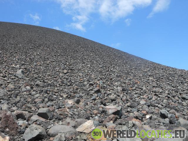
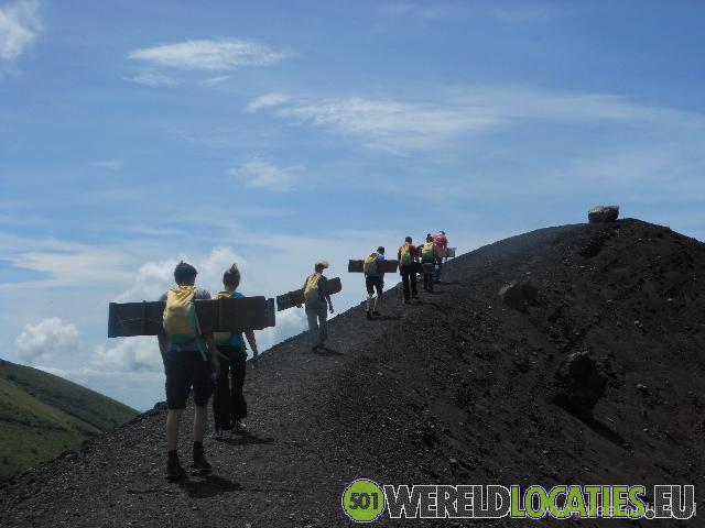
Nicaragua - Cerro Negro is a relatively young volcano, formed in 1850. The 400-meter-high volcano is very active. In recent years, it has erupted frequently. Like the Telica volcano, Cerro Negro lies on the boundary of tectonic plates, about 35 kilometers outside León. A minibus takes me to the volcano. The road is poor and narrow, but not as bad as yesterday’s route. After 1.5 hours, Franklin, my guide, points out the black volcano. It consists mostly of volcanic rocks and gravel. There’s no vegetation, making it perfect for sliding down—a popular tourist activity. At the base, I’m given a backpack with protective clothing and a board. I sling the backpack on and slide the wooden board through the straps, so it hangs behind me, keeping my hands free. But the board catches the wind on the slope, so I must watch for gusts. Franklin estimates a one-hour climb. I follow him up. The path is manageable, as it winds around the volcano, never getting too steep. At the rim, I see the wide crater bowl—a beautiful sight. A smaller crater has formed in the middle—this was the one that last erupted, Franklin says. The weather is clear, and I have views of the surrounding volcanoes, including Telica. I continue walking along the sloping rim. It must look funny from below—tourists with boards strapped to their backs. From the summit, I get a good look at the smaller crater. Franklin brushes aside some gravel and lets me feel the ground—it’s burning hot. The volcano is active just beneath our feet. Don’t stand still too long—your shoe soles might melt. After taking photos, it’s time for the fun. I put on my overall, knee and elbow pads, and goggles. I’m going sledding. Franklin explains how to steer: brake with your feet and lift the front if you want more speed. He walks ahead to take photos. Sitting at the top, the slope looks steep. I cautiously slide down the first meters. I get the hang of the board quickly and speed up. Dust flies everywhere—a true dust storm. I reach the bottom still on my board. Franklin says I hit about 40 km/h. I take off the overall and shake the dust out of my hair and clothes. The suit helped, but I’m still covered in grit. My whole face is black. Even my camera has dust inside—I probably didn’t store it properly. Hopefully, it’s not permanently damaged.

By car to the Masaya crater

Nicaragua - After about half an hour, Belisario turns off the main road, and the bus drives into the parking lot of Masaya National Park. The gate is still closed. It turns out the staff is in a meeting, so we have to wait. The Masaya volcano is one of the most active ...
Kayaking among the Isletas de Granada

Nicaragua - I take a minibus to the lake to go canoeing among the Isletas de Granada. Off the coast of Granada lie numerous small islands, which were formed by a volcanic eruption of the Mombacho volcano. Francesco is the guide this morning. He hands me a life jacket ...
Lava at the Telica volcano

Nicaragua - After more than an hour and a half, the Jeep stops at the base of the volcano. I see the mountain giant towering in front of me. A thick cloud of volcanic gas rises from the crater. Miguel, my guide for this volcano, hands me a flashlight. He also distributes ...
 The Concepcion on Isla de Ometepe

Nicaragua - At a local family’s home, a small table is set up in the yard. In the little kitchen, my breakfast is being prepared. I also meet Louis here. Louis is my guide for today, an enthusiastic 24-year-old guy. After breakfast, I'm driven to the starting point ...
The historic city of Leon

Nicaragua - In just over an hour, I arrive in León. On the way, I have a view of the Momotombo volcano. The old city of León used to lie at the foot of this volcano. When it erupted in 1523, the city was completely destroyed. The old city, León Viejo, is now on ...
The old town of Granada

Nicaragua - I’m on my way to Granada, an old colonial town located on Lake Nicaragua. Granada was founded after the Spanish invasion in 1524 and named after the Spanish city of the same name. Thanks to its favorable location 20 kilometers inland, it was an ideal ...